
So you’ve dipped your toes into hiking; you’ve been to your local hills and conquered each of the peaks; through the rain, wind, and fog, you’ve triumphed. So what’s next? You could pop over to the next county and take a look at what they have to offer. Or, if you’re up for the challenge and you’re a bit of an adrenaline junkie like me, you could turn your attention to the wealth of Snowdonia ridge walks and scrambles.
Every mountain chain in the UK has its fair share of nerve-racking hikes, but Snowdonia has, in my opinion, the best of the bunch. From the frankly iconic North Ridge of Tryfan to the lesser-known Nantlle Ridge, if you’re looking for adventure, Snowdonia Ridge walks and scrambles have you covered.
Snowdonia Ridge walks and scrambles
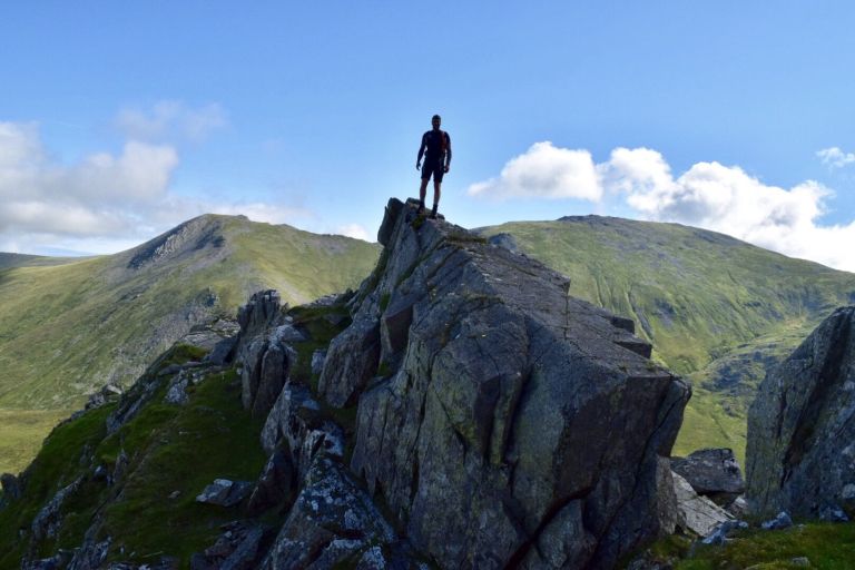
The North Ridge of Tryfan
Where: Ogwen Valley on the A5
Parking: There’s loads of parking available in the various laybys, but get there early!
Distance: 4.6 km (2.75 miles)
Summits: Tryfan


Tryfan is probably the best mountain in the UK for scrambling; the sole reason for this is the diversity of routes that you can take depending on your ability. Most people take the North Ridge, which is a grade-one scramble that follows landmarks like the start of the Heather Terrace and the Cannon Stone up to the summit.
You’ll need good scrambling skills and a head for heights to complete this route, but you’ll be rewarded at the top by stunning views over the entirety of the Ogwen Valley. The summit itself is one of only two rock peaks in Snowdonia, meaning there is little to no grass at all.
The route

Assuming you’ve parked on the large layby next to the lake, cross the road and walk in the direction away from the youth hostel. You’ll see a gate in the stone wall on your right after about 150 metres. Go through that gate, and you’ll be on the track.
Now follow the path—and the countless other hikers up. This part of the walk is really steep and quite loose but doesn’t require any scrambling. You’ll reach the first crest within half an hour and will have a large wall of stone to your right. You need to follow the course of the wall around the mountain.
Tryfan is quite a difficult mountain to navigate properly, but as a result of its massive number of routes, it is also pretty difficult to get lost on. At a certain point, a path will form off to the left; this will be a fairly gradual route and is called the Heather Terrace. You want to bear right instead and pick a route through the gulleys and crags.
About halfway up the mountain, you’ll come across the “canon stone,” a very aptly named rock formation and a brilliant place to take a photo. Now comes the trickiest part: navigating the rest of the mountain. The paths are all pretty well formed and easily identifiable, but there are a lot of them. A golden tip to make sure you don’t go out of your depth is to keep the lake on your left-hand side; if you skirt too far around the mountain, you could run into a grade 3 scramble.

Continue picking a route up the ridge until you reach the summit and see the Adam and Eve stones. If you’re feeling brave, you can climb up onto them and jump between them, but I didn’t have the minerals for this (sorry).
To complete the circular loop, just head down the South Ridge of Tryfan until you see a path that branches off to the right towards the lake. Simply head down that path and continue until you find yourself back at the A5.
Llech Ddu Spur
Where: Upper Bethesda
Parking: Limited parking in Gerlan; official parking in Bethesda
Distance: 17 km (10.5 miles)
Summits: Carnedd Dafydd, Carnedd Llewelyn, and Yr Elen
The main face of Llech Ddu Spur is a spectacular 300-meter-tall, near-vertical wall that stretches for almost 1km. Only on its far western edge is there significant enough of a break in the terrain to tempt a scrambler into attempting it.
To begin the trail, you’ll start in Gerlan and continue along a gently rising lane up towards the highest peaks and cliffs. Once you get to the first peak, you’ll see the general route open up. You need to follow the horseshoe of mountains to your left towards Yr Elen. At Yl Elen, you’ll see by far my favourite view of the day: a rugged and exposed panorama back towards Carnedd Dafydd.
Bochlwyd Horseshoe
Where: Ogwen Valley
Parking: Parking is available on laybys along the A5 and near the lake.
Distance: 6.5 km (4 miles)
Summits: Glyder Fach (optional to do Gylder Fawr as well)
The Ogwen Valley is one of my favourite spots for good reason; the rocky, exposed mountains make for some of the best and most accessible scrambling in the UK. The Bochwyd Horseshoe is a perfect example of a varied hike; one moment you’re strolling next to an idyllic mountain lake, the next you’re clambering to rockfaces as you push towards the summit.

While the route choices aren’t nearly as plentiful as at Tryfan just next door, the Bochwyd Horseshoe gives you a variety of terrain that Tryfan just can’t compete with. The route is actually really easy and pretty clearly marked through the abundant foot traffic.
The route

You simply need to head to the Llyn Bochwold (the lake halfway up the mountain), follow the footpath that leads to the left of it, and once you reach the top of the ridge, take a right up Glyder Fach.
The ascent up Glyder Fach is quite exposed, and some of the terrain is really loose, depending on the route you take. If you fancy a tough scramble, you can pick a route through the rock crags on the right-hand side of the path. If you’d rather have something a bit more chilled, the main path follows a scree route to the left of the scrambling route.
But once you reach the top, it all opens up, and you’ll be greeted by an incredible view of the entire Ogwen Valley, including Tryfan. Once you’ve had your fill of time exploring the unique rock formations at the top of Fach, follow the summit running parallel to the lake hundreds of feet below you and look for a faint path that follows the narrow ridge that descends towards the youth hostel.
It’s not easy to find this path, especially when the weather isn’t great, but it gets a lot easier as you go further down. Descend the ridge until you’re almost level with the lake; you will see a path that juts off to the right and to the original path. Take this and continue onto the path by the lake, then finally turn left and head back towards the A5 and your car.
The Northern Glyderau
Where: Ogwen Valley
Parking: Parking is available on laybys along the A5 and near the lake.
Distance: 12 km/7.5 miles
Summits: Myndd Perfedd, Carnedd Filiast, and Elidir Fawr
Yet another gem of the incredible Ogwen Valley, the Norther Glyderau is definitely the lesser known of the incredible ridge walks and scrambles in this area for one simple reason: ease of access. However, if you persevere, you’ll be met by a superb grassy route through the ridges offering brilliant views of Nant Ffrancon, Y Garn, Glyder Fach, and a little bit of Glyder Fawr.

The Route
The route is a little more complex than everything else so far; you’ll want to start at the youth hostel at the north end of Llyn Ogwen. From there, you want to walk through the small pine forest in a general northern direction, keeping the imposing stone wall of Pen Yr Ole Wen to your right and Foel Goch to your left. Shortly after emerging from the forest, you’ll come across a small climbing hut. You want to keep left across the parking lot until you pick up a faint path leading to a ladder stile over a fence.
After this, follow a footpath to your right, skirting around the bottom of Foel Goch. You will soon come across another ladder stile. Climb over this and begin your ascent to the grassy ridge of Cwn Perfedd. Carry on ascending until you reach the top of the next ridge (don’t worry, the path will get clearer as you continue).
Once you reach the top, turn right and continue until your first summit, Carnedd y Filiast, before backtracking along the same ridge to Mynedd Perfedd. At the summit of Mynedd Perfedd, continue in the same direction to your final summit of Elidir Fawr before heading back down to the youth hostel via Foel Goch.
Snowdon Horseshoe
Where: Pen Y Pass
Parking: There is moderate parking at Pen Y Pass itself, but this is often full. Pen Y Gwryd or Nant Peris Park & Ride are good alternatives.
Distance: 12 km/7.5 miles
Summits: Crib Goch, Crib y Ddysgl, Snowdon, and Y Lliwedd
Perhaps the most iconic hike anywhere in the UK, the Snowdon Horseshoe loops around the stunning, rugged terrain of the UK’s highest peak south of the Scottish border. You can expect sustained, exposed scrambling on long, spectacular rock ridges. Pre-warning: this is really exposed in some areas!

The magnificent route provides moderate, exposed scrambling for much of the duration. There are a few places where you will need to take additional care because a fall would be really serious, in particular on the Crib Goch pinnacles. I thoroughly believe that this route offers the best scrambling south of the Scottish Highlands; it follows the skyline of Cwn Dyli, the two great ridges of Y Lliwedd, and the infamous Crib Goch.
The Route

You will start this adventure at the Pen Y Pass car park. Take the miners path out of the car park for about 300 meters. Around this point, you will see a faint but noticeable grassy path breaking away to the right. Follow this path up onto the grassy ridge of Llyn Llydaw, where you will find an incredible view of Crib Goch, Snowdon, and the surrounding area.
Soon you will join up with the Pyg Path; follow this until you see the marker for Crib Goch on your right. Climb over the stile and follow the path to the start of the incredible Crib Goch pinnacles. Before you will be the infamous Crib Goch ridge, stretching on for about 300 metres of exposed scrambling. Once you’ve conquered the ridge, continue upwards until you rejoin the Pyg Path again; shortly after, you will reach the summit of Snowdon.
On your way down, you want to follow the Watkin path, which runs diagonally down the mountain until you reach Bwlch y Saethau, where the path levels out. Continue on until you re-join the marked miners path, then simply follow this all the way back to Pen Y Pass, the finish line, and hopefully a celebratory pint.
Gwn Glas Ridges
Where: Blaen Y Nant on the A4086
Parking: Lay-bys on the A4086 or Nant Peris if they are full.
Distance: 7 km/4.5 miles
Summits: Crib Goch, Crib y Ddysgl (Snowdon optional)
The wild and rugged ridges of Cwm Glas Mawr and Cwn Uchaf are perfect for those who want to experience exposed and excellent scrambling without the crowds on the much more popular Snowdon Horseshoe. This route uses the best (and hardest) sections of the aforementioned Snowdon Horseshoe, with an ascent up the less frequented north ridge of Crib Goch and a descent of the almost unknown Gyrn Las Ridge. The views on this route are second to none and really enforce the feeling of being truly in the wild; there are no coffee shops or crowds, unlike on Snowdon.

The Route
Start the route in Blaen y Nant, cross over the stile and the wooden bridge, and continue following the path and the stream uphill until you get to the lake on your left-hand side. Pass the lake and head up to the imposing sight of Crib Goch’s north ridge. This path starts steep and loose, but soon the ridge narrows, and things become a little bit easier and a lot more interesting.
From here, follow the Crib Goch ridge until it reaches its conclusion, and you will find yourself at the summit of Crib y Ddysgl. At this point, it will be a left turn to the summit of Snowdon, but you want to head right, following the path to join the Gyrn Las Ridge. This will be the final ridge of the day to traverse; continue on this until you see a large crag with distinct water staining. At this point, bear right and descend to the path you started the hike on.
Nantlle Ridge
Where: The village of Rhyd-Ddu on the A4085
Parking: There are car parks to the south of the village.
Distance: 14 km (8.75 miles)
Summits: Y Garn, Myndd Drws-y-coed, Trum Y Ddysgl, Myndd Tal Y Migdedd, and Craig Cwn Silyn
The wall of hills that lie south of Nantlle are linked by a gracious, grassy ridge, providing one of Snowdon’s most enjoyable ridge walks. This is a criminally underrated hike that has just now started to gain some recognition, so expect it to start getting really busy soon.

The only real negative of this walk is that it’s hard to make it a thrilling circular hike like the Snowdon Horseshoe’s. But the lack of crowds, gentle ridges, and low-level scrambling make up for this negative.
The Route

Staring in the iddylic village of Rhyd Ddu, head over the kissing gate and onto a footpath that leads across a damp and flat field. Shortly, this path will take you to the B4418. Don’t go onto the road; instead, take the marked path on your left and right and start the gruelling climb up to the summit of Y Garn. The path will soon fork off to the left and right, and you will see a large rock with a white arrow painted on it heading towards the woods on the left. Ignore this and continue on the right-hand path until you arrive at the summit of Y Garn.
From here, follow the ridge before you until you reach the summit of Myndd Drws-y-Coed. Just before you reach the summit, you’ll reach the climax of the scrambling on this route. There is some exposure in this section, so if big drops aren’t your thing, keep to the left to avoid the worst of it.
With the worst of the scrambling over, what follows now is a narrow, but grassy, and gradual ridge that takes you to Myndd Tal Ymigdedd (you’ll know you’re there from the obelisk at the summit). The next summit is Craig Cwn Silyn, which marks the highest point of this hike and also the point where you need to head back.
As I mentioned, it’s not really possible to do this track in a completely circular route, so you need to go back down the same path, passing Myndd Tal Y Migdedd again and continuing until you reach Trum Y Ddysgl again. From here, simply take a right and descend, walk through the woods, and you will find yourself back at the B4118.
Cnicht & Moelwyn Mawr
Where: The village of Croesor
Parking: Free National Park car park in the village
Distance: 12.5 km (7.75 miles)
Summits: Cnicht and Moelwyn Mawr

Few travellers on the A498 in the area can fail to be impressed by the striking pyramidal peak jutting out of the landscape, like the Matterhorn. However, unlike the actual Matterhorn, you can climb it with no experience and very little in the way of equipment. This route uses one of the mountains most conspicuous features—a long, narrow ridge up to the summit, followed by another ridge on the neighbouring Moelwyn Mawr to form a fantastic horseshoe track.
The route

Turn right out of the car park and follow the rising lane out of the village, where the track levels bear right, and head up the good footpath that points directly to Cnicht’s pointed summit. This eye-catching summit will remain in view for the duration of the hike. Higher up, you’ll come across a small ruin; bear right at it as directed by the way marker.
Follow this path as it rises up the mountain, more or less following the ridgeline towards the summit. As you get closer to the summit, there is a short scramble on the final push. Don’t worry though; it’s not too difficult and is nowhere near as exposed as some of the hikes on this list.
Once you’ve reached the summit and you’ve finished taking in the spectacular views, continue east over the summit plateau, which lies at the heart of Moelwynion. Thankfully, this path is well used and easily identifiable. The path will soon fork at a cairn, turn right here, and continue past the lake that will be on your left-hand side. Next, you’ll need to take a slight left past the ruined mine buildings and onto another ridge up to the summit of Moelwyn Mawr.
For the final stage of this circular, follow the final—and thankfully quite gradual—ridge down that runs parallel to Cnich’s ridgeline. This is a fantastic descent with views over Cardigan Bay. As you get closer to the bottom of the ridge, you’ll see a farm track to follow. This track will lead to a right turn that will bring you back to the starting point.
Rhinog Fach & Y Llethr
Where: 12 km/7.5 miles
Parking: There is a small parking area at the head of Cwm Nantcol near the Maes Y Garnedd farm.
Distance: 12 km/7.5 miles
Summits: Rhinog Fach & Y Llethr
Despite its reputation for rough and rocky terrain, the Rhinog does have a few pleasing ridges for avid trekkers to negotiate. One massive positive for Rhinog Fach & Y Llethr is that the views are just as good as anywhere else on this list, but they are much less exposed for most of the journey. If you struggle with heights or your nerves while trekking, this one might be perfect for you.
The route
To start this route, head up the lane, and under the overhead cables, you will be able to see some stepping stones over a stream. Hope over those and continue up the path; as you go further up, the valley will get tighter and tighter to the path. You will pass a prominent rock streaked by white quartz as you approach the top of Bwlch Drws Ardudwy Pass.
Cross a marshy area using the stepping stones and bear right to cross a stile over the wall, then take the steep, narrow path through the heather that clings to the mountain. After a tough, steep walk up the path, you’ll arrive at your first summit, Rhinog Fach, and will be looking out at a mountain lake and Y Llethr. Don’t be too discouraged by the sight of Y Llethr; it looks like it will be tough—and it will, but it is definitely worth the effort.
Enough time admiring the view; it’s time to crack on! Descend from Rhinog Face using the path that skirts around the left-hand side of the lake and follow the path up Y Llethr. As you’re climbing up Y Llethr, just follow the wall until you reach the cairn right at the top.
From here, follow the wall southwest to the corner where there are two stiles, cross the stile ahead, and then turn right, following the broad ridge with the grassy dome of Moelfre dead ahead. Once you’ve crossed the ridge, there will be about 2 kilometres until the wall turns right. Follow the course of the wall until you see a gateway in the wall. Go through that gateway; you should then see a rough track to follow just on the other side of the stream. Follow this track until you reach the road, and you’ll be back at your car.


